The maps below show the centre of a small town called Islip as it is now, and plans for its development.
The maps below show a town called lincoln as it is at present for its development.
Summarize the information by selecting and reporting the main features and make comparisons where relevant.
Intro:
- The two maps indicate how town of Lincoln is expected to change after the development.
- The pair of maps indicates the changes that city called Lincoln is expected to undergo
Vocabulary for MAP
- General: developed, redeveloped, transformed, converted, changed, improved
- Building: renovated, demolished, extended, constructed, relocated, flattened
- Road, Bridge: constructed, built, extended, expanded, removed
- Facilities: opened, set up, developed, enlarged, introduced
- Trees and Forests: cleared, cut-down, chopped-down, removed, planted
Overview
- Overall, it can be seen that...
- Overall, a comparison of the two maps shows that ...
First part
- The area witnessed dramatic changes over the period shown.
- From 1995 to 2005, the city center saw significant developments.
- The village changed considerably over the time period.
- During the 10-year period, the industrial area was totally transformed.
- Over the past 20 years, the residential area was totally reconstructed.
- Over the tome period, the region was totally redeveloped.
- Between 1995 and 2005, the old houses were rebuilt.
- The central district was completely modernized during the time period.
- The are changed from largely rural to a mainly urban landscape.
Second part
- ..., specially with respect to the .... infrastructure.
- In particular the .... facilities were upgraded.
- ..., changing from a .... to a ....
Overall, it can be seen that the town the town witnessed dramatic changes over the period shown, specifically with respect to the road infrastructure.
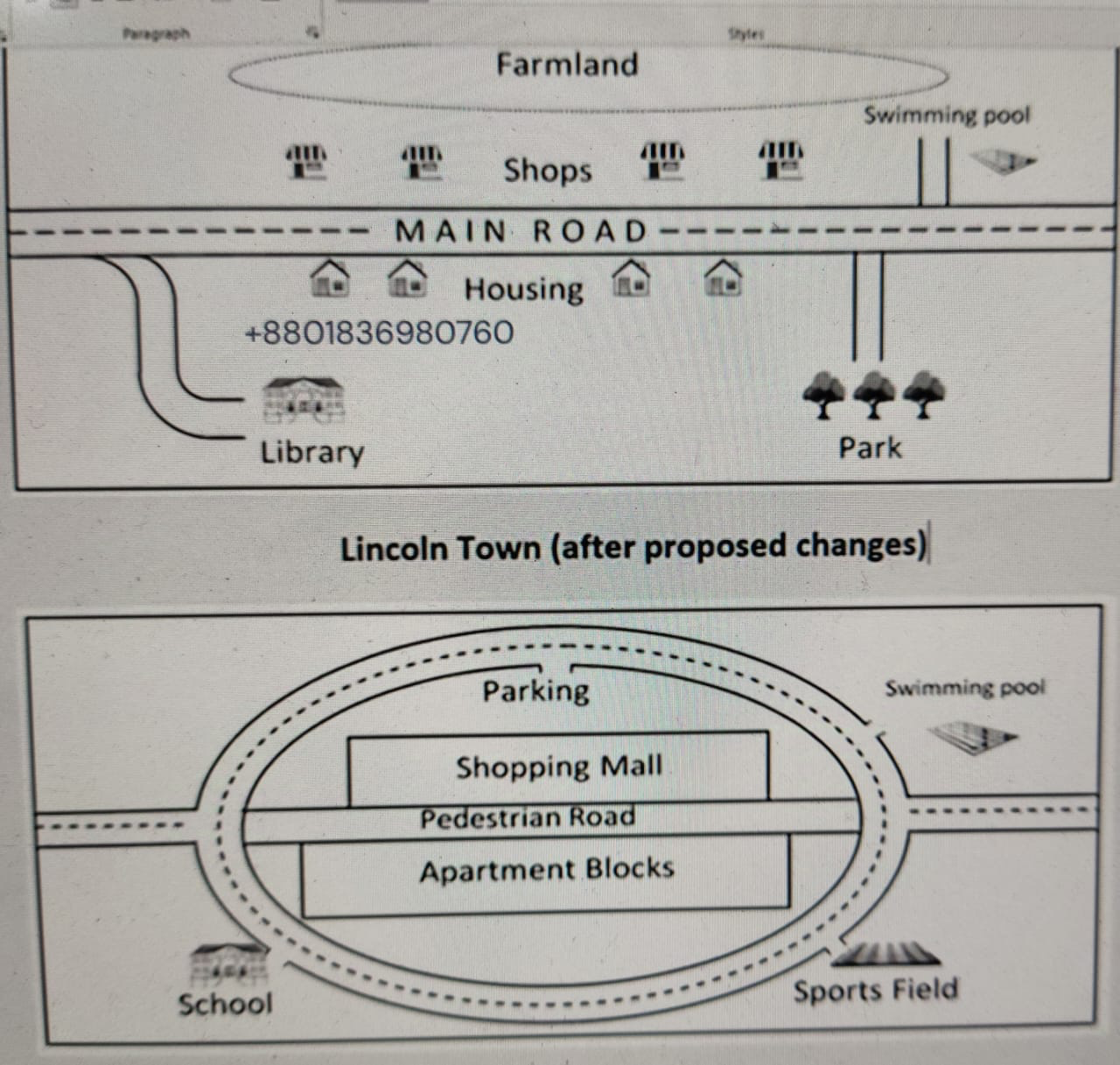
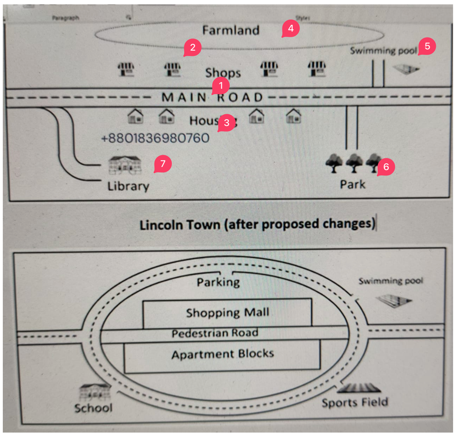
Looking at the first map in more details, it is clear that the central feature of Lincoln town is the Main Road, which runs through the town. On the north side of the Main Road there are a number of shops, whereas, ....
- on the south side there is housing.
- the south side is occupied by housing.
Behind the shops there is a farmland. East of the town, a small road leads north to swimming pool and another small road leads south to a park. In the south-west of the town, a curved road leads to the library.
Body 2
Turning to the second map.....
The map of the town after proposed changes, looks distinctly different. Perhaps the most striking change is that the road system is anticipated to be expanded to include a ring road, which will incircle the town. The shops are expected to be replaced by shopping mall, which will have a parking area behind it. The farmland will be removed. The section of the Main Road inside the roundabout will be converted into a pedestrian road and apartment blocks will replace the houses. The library is expected to converted into a school and the park into a sports field whereas the swimming pool will remain unchanged. Access to all of these facilities will be provided by the ring road.
Final Output
The pair of maps indicates how the changes that city called Lincoln is expected to undergo.
Overall, it can be seen that the town the town witnessed dramatic changes over the period shown, specifically with respect to the road infrastructure.
Looking at the first map in more details, it is clear that the central feature of Lincoln town is the Main Road, which runs through the town. On the north side of the Main Road there are a number of shops, whereas the south side is occupied by housing. Behind the shops there is a farmland. East of the town, a small road leads north to swimming pool and another small road leads south to a park. In the south-west of the town, a curved road leads to the library.
The map of the town after proposed changes, looks distinctly different. Perhaps the most striking change is that the road system is anticipated to be expanded to include a ring road, which will incircle the town. The shops are expected to be replaced by shopping mall, which will have a parking area behind it. The farmland will be removed. The section of the Main Road inside the roundabout will be converted into a pedestrian road and apartment blocks will replace the houses. The library is expected to converted into a school and the park into a sports field whereas the swimming pool will remain unchanged. Access to all of these facilities will be provided by the ring road.